Real scholarship vs. gut feeling
Jonathan Neville opines:
Contra Neville, the text of the Book of Mormon is very consistent and meticulous in the way it describes distances between lands and cities: Based on the time it took individuals and groups to travel from one place to another, John Sorenson has concluded that the Book of Mormon took place in an area that was “on the order of five hundred miles long and over two hundred miles wide.”
Sorenson’s scholarly approach is vastly better than Neville’s “gut feeling.”
—Peter Pan
* “M2C” is Jonathan Neville’s acronym for the theory that the Book of Mormon took place in Mesoamerica and that the hill Cumorah in the Book of Mormon is not the same hill in New York where Joseph Smith received the plates of Mormon.
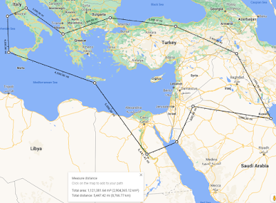
It’s not plausible to me to think that in 1,000 years, the Nephite civilization was confined to a “limited geography” in Mesoamerica. The idea that the Jaredites were confined to such a small area is even less plausible.Why he believes it’s not plausible he doesn’t bother to tell us. It just doesn’t feel right to him, I suppose, because the Biblical narrative took place on such a large scale, as he demonstrates with this map:
Neville’s map of the area of the Bible is completely disingenuous, though: The vast majority of the Biblical narrative took place exclusively in the land of Israel, which, at around 11,000 square miles, was about the size of Massachusetts. The far corners of his plot were never settled by Israelites; they were only visited by individuals who were carried away as captives (e.g., Joseph and Ezekiel), or who were forced to flee Israel to avoid persecution (e.g., early Christians in Damascus and Antioch), or who were on traveling ministries (e.g., Paul).
Bible area: 1,121,000 square miles
Contra Neville, the text of the Book of Mormon is very consistent and meticulous in the way it describes distances between lands and cities: Based on the time it took individuals and groups to travel from one place to another, John Sorenson has concluded that the Book of Mormon took place in an area that was “on the order of five hundred miles long and over two hundred miles wide.”
Sorenson’s scholarly approach is vastly better than Neville’s “gut feeling.”
—Peter Pan
* “M2C” is Jonathan Neville’s acronym for the theory that the Book of Mormon took place in Mesoamerica and that the hill Cumorah in the Book of Mormon is not the same hill in New York where Joseph Smith received the plates of Mormon.


I was at Mesa Verde last November, and asked the ranger about evidence for contact between the Ancestral Puebloans (Anasazi) of the Colorado Plateau and the contemporary Mississippian culture – the "Mound Builders" of Cahokia and other eastern pre-Columbian cities, both occupying a much larger geographical footprint than the "M2C" model. His eyes literally lit up. I learned that there is an abundance of evidence for trade between not only those groups, but they have found traces of cacao (MesoAmerican!) in pot sherds found at MVNP, Chaco and other sites in the region. They seem to have mixed cacao with an eastern holly-derived compound, making a potent, caffeinated chocolate drink (http://westerndigs.org/use-of-cocoa-black-drink-widespread-in-pre-contact-southwest-study-finds/). The Camino Real between Santa Fe and Mexico DF predates the Conquistadores by centuries.
ReplyDeleteBut trade relations and routes are not the same as local cultures. Merchant contact doesn't mean that the Ancestral Puebloans were more widespread than the evidence demonstrates, (through most of history, you were far more likely to remain near your birthplace throughout your lifetime; even most Venetians probably never left the lagoon), it means that those who did travel, the Pauls and Marco Polos, are outliers, as are military expeditions. The map above would be more effective as an illustration of "Bible Lands" if it simply highlighted the Levant with some arrows between there and distant places like Memphis, Thebes, Babylon and Rome – with the understanding that those are as far removed from each other in time as we are from the Day of Pentecost. Biblical geography owes more to Rome's influence (and preceding empires) for its geographical footprint than anything the Hebrews did; Judea is a Roman footnote. There is much more to unpack here, but this is getting too long for a blog comment.
The map illustration above is simply too de-contextualized to be of any value. Besides pretending that all ancient cultures are the same, it's shouting "Because the Bible [oversimplified]!" as if that ends any discussion (much like in flat earth circles, but based on their "Universal Model", they seem to be headed in that direction anyway).